|
Size: 415
Comment:
|
Size: 5104
Comment:
|
| Deletions are marked like this. | Additions are marked like this. |
| Line 3: | Line 3: |
| Wind, hail, ice accumulation and lightning are hazards for launch loops, deflecting or damaging the incline track. A launch loop should be able to survive 20 year and perhaps 50 year extremes in these conditions. | Wind, hail, ice accumulation and lightning are hazards for launch loops, deflecting or damaging the incline track. A launch loop should be able to survive 20 year and perhaps 50 year extremes in these conditions. The launch loop will be built over the equatorial ocean, far from large populations, in case of failure. So our concern is the weather over the best sites in the equatorial ocean. |
| Line 5: | Line 5: |
| Steady winds can be accommodated by changing the deflection angles at the ground. | Predictable, slowly changing winds can be accommodated by changing the deflection angles at the ground. Unpredictable gusty winds will add forces that can lead to instability and failure. How much wind can we accommodate? Assume that the peak wind is 39 knots, westerly (blowing from west to east) about 20 meters per second. The cross section of the launch loop through the atmosphere is about 0.1 meters, with a drag coefficient of about 1. It traverses the troposphere and lower stratosphere (up to an estimated 20km) at an angle of about 19 degrees, thus exposing about 60km of forward and reverse track to the wind, an area of 12000m^2^ . The higher altitude air is less dense, but may be moving faster. The drag is the density (1.2kg/m^3^) times the velocity squared times the drag coefficient and area - 480 Pa * 12000 m^2^ = 5.8E6 Newtons, which deflects the tracks by about 0.01 radians or about 0.6 degrees. While that seems small, if uncorrected that is enough to miss the stations by 3 kilometers. Since the spacing accommodation of the track and station magnets is on the order of 5 millimeters, we would need to be able to measure and predict the average wind along the track with an error less than 1 part per million over the 20 seconds between the time the rotor leaves the station and the time it passes through the troposphere. We can deal with unpredictable gusty winds in seven ways, in order of cost: 1) locate the launch loop in areas with very low wind shear 2) get extremely good at wind measurement and prediction over the next 30 seconds 3) add moving counterweights near the track 4) add actively adjusted tensioning cables to the ground 5) add propulsion devices along the track (propellers, shutters) 6) scale up the mass-to-area ratio 7) accept a higher failure rate |
| Line 8: | Line 26: |
| It is not wind that causes the problem, it is variable winds, which are caused by wind shear and turbulence. Where two air masses move past each other at different speeds or in different directions there will be wind shear, which causes rotating vortexes near the boundary. Where high moisture hot air rises through low moisture air, the air column is unstable, and there will be up and down drafts. The air mostly heats via the ocean surface, so shading by scattered clouds create cooler and warmer patches, with differing upward air flows, and more opportunities for eddies and turbulence. The air movements involve megatons of air moving over large distances; air viscosity does little to remove energy until the volumes become small, or at the surface. All these effects make the winds chaotic and hard to predict. | |
| Line 9: | Line 28: |
| {{attachment:sites.png|world map with hurricane tracks|width=768}} | {{{ Big whorls have little whorls That feed on their velocity, And little whorls have lesser whorls And so on to viscosity. -- Lewis F. Richardson, pioneer of numerical weather prediction }}} The map below shows the tracks of hurricanes for the last century, and the range of the Inter Tropic Convergence Zone (ITCZ), from the southern line in January to the northern line in July. The zone is where westerly trade winds from the southern and northern hemispheres merge and rise, driven by hot moist air from the summer ocean. Hurricanes generally start in the tropics, north of 5 degrees north latitude, or south of 5 degrees south latitude. {{attachment:sites1.png|world map with hurricane tracks|width=768}} 2800 km east-to-west launch loops are shown below the ITCZ and the hurricane belts, in the southern Atlantic between Brazil and Africa, and in the southwest Pacific off Ecuador and Peru. The first launch sites are south of Europe, and the second sites are south of the United States. Unfortunately, there are no good sites south of Asia, or at temperate latitudes. Until launch loops can scale large enough to ignore the wind, wind gusts will be show-stopper. Launch loops are very difficult to build over land, the wind forces are chaotic, and they are too dangerous to locate near cities, so they will only be built over the ocean. As launch loops grow more reliable, and operators become more adept at containing failures, they can be spaced closer together, perhaps within a few kilometers north-south. This, combined with very massive launch loops, means these zones may someday be launching millions of tons into orbit per hour, approaching the cargo capacity of the world's seaports. Here is a closeup of the launch loop zones east and west of South America: {{attachment:sites2.png|launch loop zones}} MORE LATER: Wind patterns near the Galapagos? Upper air vortices? Upper air wind direction around equator? |
Wind Effects on the Launch Loop
Wind, hail, ice accumulation and lightning are hazards for launch loops, deflecting or damaging the incline track. A launch loop should be able to survive 20 year and perhaps 50 year extremes in these conditions. The launch loop will be built over the equatorial ocean, far from large populations, in case of failure. So our concern is the weather over the best sites in the equatorial ocean.
Predictable, slowly changing winds can be accommodated by changing the deflection angles at the ground. Unpredictable gusty winds will add forces that can lead to instability and failure. How much wind can we accommodate?
Assume that the peak wind is 39 knots, westerly (blowing from west to east) about 20 meters per second. The cross section of the launch loop through the atmosphere is about 0.1 meters, with a drag coefficient of about 1. It traverses the troposphere and lower stratosphere (up to an estimated 20km) at an angle of about 19 degrees, thus exposing about 60km of forward and reverse track to the wind, an area of 12000m2 . The higher altitude air is less dense, but may be moving faster. The drag is the density (1.2kg/m3) times the velocity squared times the drag coefficient and area - 480 Pa * 12000 m2 = 5.8E6 Newtons, which deflects the tracks by about 0.01 radians or about 0.6 degrees. While that seems small, if uncorrected that is enough to miss the stations by 3 kilometers. Since the spacing accommodation of the track and station magnets is on the order of 5 millimeters, we would need to be able to measure and predict the average wind along the track with an error less than 1 part per million over the 20 seconds between the time the rotor leaves the station and the time it passes through the troposphere.
We can deal with unpredictable gusty winds in seven ways, in order of cost:
- 1) locate the launch loop in areas with very low wind shear 2) get extremely good at wind measurement and prediction over the next 30 seconds 3) add moving counterweights near the track 4) add actively adjusted tensioning cables to the ground 5) add propulsion devices along the track (propellers, shutters) 6) scale up the mass-to-area ratio 7) accept a higher failure rate
It is not wind that causes the problem, it is variable winds, which are caused by wind shear and turbulence. Where two air masses move past each other at different speeds or in different directions there will be wind shear, which causes rotating vortexes near the boundary. Where high moisture hot air rises through low moisture air, the air column is unstable, and there will be up and down drafts. The air mostly heats via the ocean surface, so shading by scattered clouds create cooler and warmer patches, with differing upward air flows, and more opportunities for eddies and turbulence. The air movements involve megatons of air moving over large distances; air viscosity does little to remove energy until the volumes become small, or at the surface. All these effects make the winds chaotic and hard to predict.
  Big whorls have little whorls
   That feed on their velocity,
 And little whorls have lesser whorls
   And so on to viscosity.

  -- Lewis F. Richardson, pioneer of numerical weather prediction
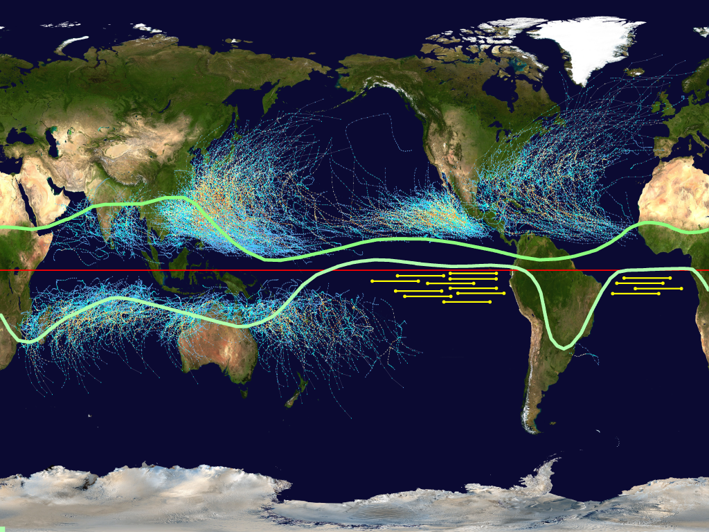
The map below shows the tracks of hurricanes for the last century, and the range of the Inter Tropic Convergence Zone (ITCZ), from the southern line in January to the northern line in July. The zone is where westerly trade winds from the southern and northern hemispheres merge and rise, driven by hot moist air from the summer ocean. Hurricanes generally start in the tropics, north of 5 degrees north latitude, or south of 5 degrees south latitude.

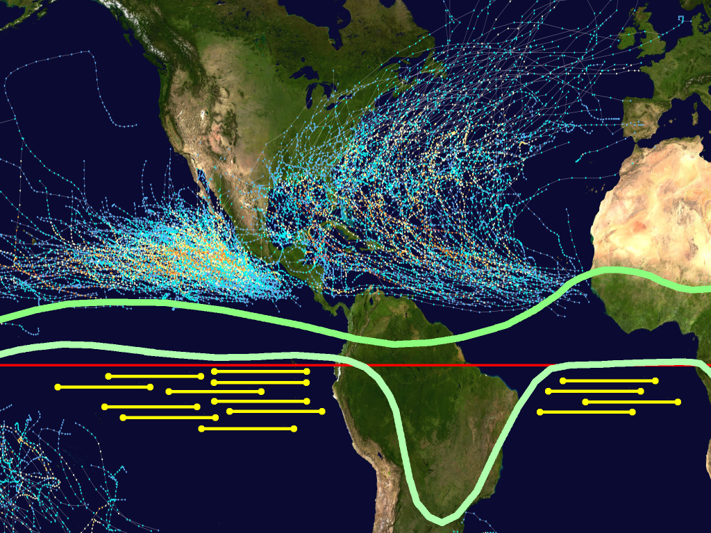
2800 km east-to-west launch loops are shown below the ITCZ and the hurricane belts, in the southern Atlantic between Brazil and Africa, and in the southwest Pacific off Ecuador and Peru. The first launch sites are south of Europe, and the second sites are south of the United States. Unfortunately, there are no good sites south of Asia, or at temperate latitudes. Until launch loops can scale large enough to ignore the wind, wind gusts will be show-stopper. Launch loops are very difficult to build over land, the wind forces are chaotic, and they are too dangerous to locate near cities, so they will only be built over the ocean. As launch loops grow more reliable, and operators become more adept at containing failures, they can be spaced closer together, perhaps within a few kilometers north-south. This, combined with very massive launch loops, means these zones may someday be launching millions of tons into orbit per hour, approaching the cargo capacity of the world's seaports.
Here is a closeup of the launch loop zones east and west of South America:

MORE LATER:
Wind patterns near the Galapagos?
Upper air vortices?
Upper air wind direction around equator?
