|
Size: 11133
Comment:
|
← Revision 36 as of 2019-05-04 21:18:05 ⇥
Size: 12402
Comment:
|
| Deletions are marked like this. | Additions are marked like this. |
| Line 52: | Line 52: |
| === More About the ITCZ == | === More About the ITCZ === |
| Line 57: | Line 57: |
A [[ http://www.the-islander.org.ac/art_8473_26_11_1.html | recent report ]] of a thunderstorm at Ascension Island, 8 degrees south. Ascension Island and Galapagos Archipelago [[ WeatherPictures | weather pictures here ]]. |
|
| Line 77: | Line 79: |
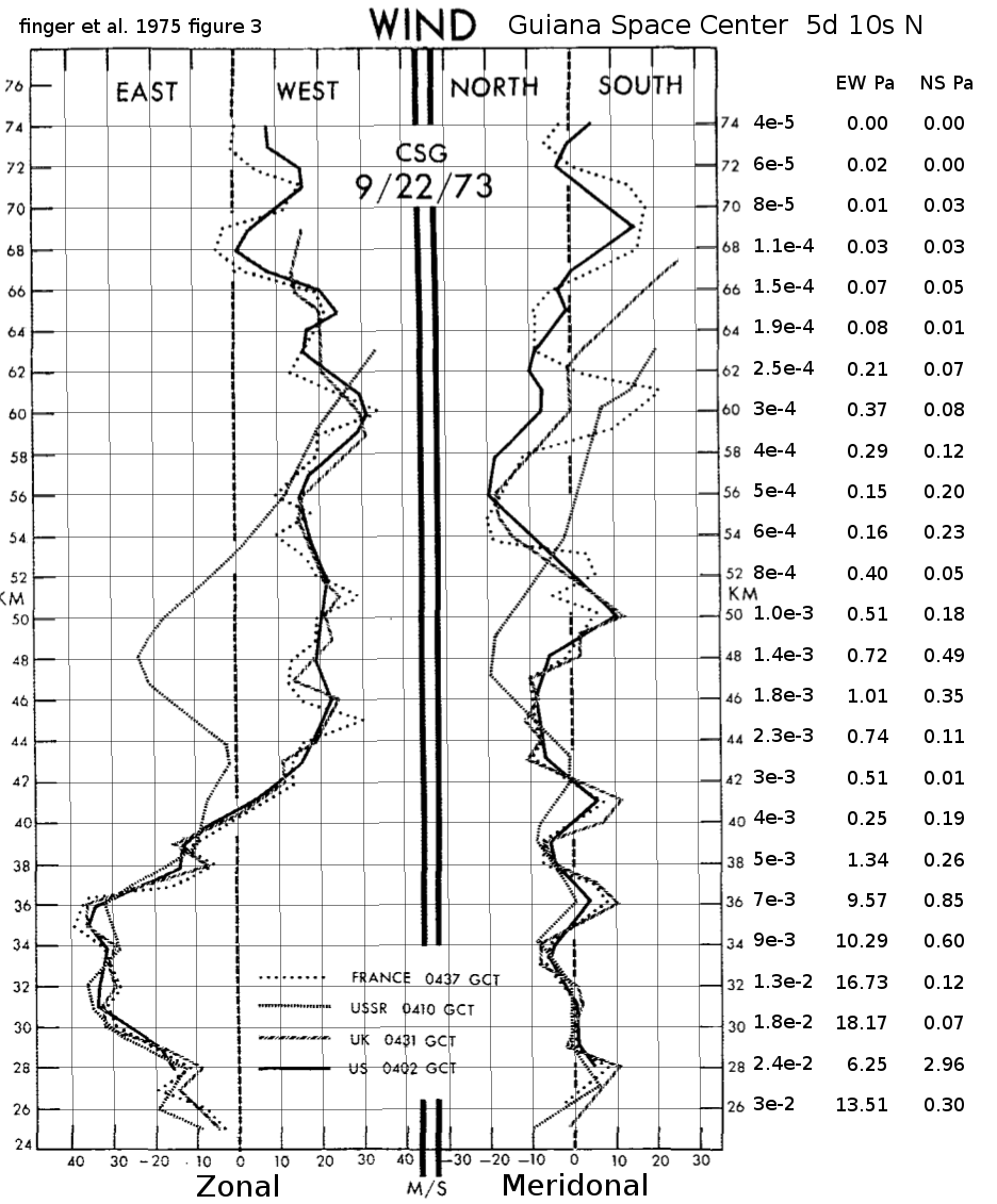
| . [[ http://journals.ametsoc.org/doi/abs/10.1175/1520-0469%281975%29032%3C1705:COMRDA%3E2.0.CO%3B2 | Compatibility of Meteorological Rocketsonde Data as Indicated by International Comparison Tests ]] September 1975. [[ attachment:GuianaWinds.pdf | download ]] see [[ attachment:GuianaWinds.pdf | figure 3 ]] || [[ attachment:GuianaWindsFig3g.png | {{ attachment:GuianaWindsFig3g.png | | height=200 }} ]] This is a one-time measurement, typical scaling. I'd multiply the dynamic pressure for 10 for normal operations ( 3 sigma, 99.7% availability ) and 50 ( 7 sigma, 2.6 parts per trillion ) for worst case system survival || [[ http://onlinelibrary.wiley.com/doi/10.1002/qj.49708737305/full | . Ebdon, R. A., 1961, "Some Notes on the Stratospheric Winds at Canton and Christmas Island," Quarterly Journal of the Royal Meteorological Society, V. 87, p322. ]] |
|
| Line 78: | Line 87: |
=== Wind Animations === . [[ https://earth.nullschool.net/#2019/05/04/2100Z/wind/isobaric/1000hPa/orthographic=-120,-8,1168/loc=-120.000,-8.000 | WindAt100m ]] . |
Wind Effects on the Launch Loop
Wind, hail, ice accumulation and lightning are hazards for launch loops, deflecting or damaging the incline track. A launch loop should be able to survive 20 year and perhaps 50 year extremes in these conditions. The launch loop will be built over the equatorial ocean, far from large populations, in case of failure. So our concern is the weather over the best sites in the equatorial ocean.
Predictable, slowly changing winds can be accommodated by changing the deflection angles at the ground. Unpredictable gusty winds will add forces that can lead to instability and failure. How much wind can we accommodate?
Assume that the peak wind is 39 knots (for example, in a thunderstorm), westerly (blowing from west to east) about 20 meters per second. The cross section of the launch loop through the atmosphere is about 0.1 meters, with a drag coefficient of about 1. It traverses the troposphere and lower stratosphere (up to an estimated 20km) at an angle of about 19 degrees, thus exposing about 60km of forward and reverse track to the wind, an area of 12000m2 . The higher altitude air is less dense, but may be moving faster. The drag is the density (1.2kg/m3) times the velocity squared times the drag coefficient and area - 480 Pa * 12000 m2 = 5.8E6 Newtons, which deflects the tracks by about 0.01 radians or about 0.6 degrees. While that seems small, if uncorrected that is enough to miss the stations by 3 kilometers. Since the spacing accommodation of the track and station magnets is on the order of 5 millimeters, we would need to be able to measure and predict the average wind along the track with an error less than 1 part per million over the 20 seconds between the time the rotor leaves the station and the time it passes through the troposphere.
We can deal with unpredictable gusty winds in seven ways, in order of cost:
- locate the launch loop in areas with very low wind shear
- get extremely good at wind measurement and prediction over the next 30 seconds
- add moving counterweights near the track
- add actively adjusted tensioning cables to the ground
- add propulsion devices along the track (propellers, shutters)
- scale up the mass-to-area ratio
- accept a higher failure rate
It is not wind that causes the problem, it is variable winds, which are caused by wind shear and turbulence. Where two air masses move past each other at different speeds or in different directions there will be wind shear, which causes rotating vortexes near the boundary. Where high moisture hot air rises through low moisture air, the air column is unstable, and there will be up and down drafts. The air mostly heats via the ocean surface, so shading by scattered clouds create cooler and warmer patches, with differing upward air flows, and more opportunities for eddies and turbulence. The air movements involve megatons of air moving over large distances; air viscosity does little to remove energy until the volumes become small, or at the surface. All these effects make the winds chaotic and hard to predict.
  Big whorls have little whorls
   That feed on their velocity,
 And little whorls have lesser whorls
   And so on to viscosity.

  -- Lewis F. Richardson, pioneer of numerical weather prediction
The unitless Reynolds number is the characteristic velocity V times the characteristic length L divided by the kinematic viscosity \nu (nu). \nu is approximately 1.5E-5 at sea level, increasing to 1E-4 at 17 km altitude as air density and temperature decreases. If the Reynolds number is greater than approximately 5E5, there will be turbulence. At sea level, that means V L is greater than 7.5 m2/s, say a velocity difference of 1 cm per second over a distance of 750 meters. A thunderstorm makes a rotating vortex about 25 km across, with velocities on the opposite sides differing by 40 m/s, for a Reynolds number on the order of 1E10 - very turbulent. As Richardson points out, this big whorl will be surrounded by many little whorls, and those will be surrounded by lesser whorls, down to scales of perhaps 50 meters (WAG). If the thunderstorm ground speed is on the order of 10m/s, then the average rate of change of wind speed might be 1 meter per second per minute, but is likely to be a lot higher - meters per second per second - because of gusting, which is how we perceive these lesser whorls as they whiz by. At altitude, they are not only whizzing horizontally, but vertically.
This needs a LOT more study! However with good Doppler radar, and possibly some small tethered balloons nearby, and some powerful computing, it may be possible to predict the wind speeds to moderate accuracy over the next 50 seconds or so, allowing angle shifts at the stations and the inclines, revving propellers, and adjusting shutters.
Weather, Storms, and Hurricanes
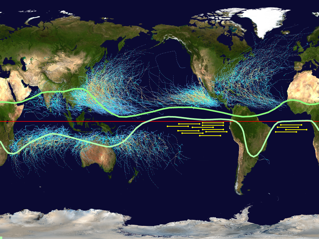
The map below shows the tracks of hurricanes for the last century, and the range of the Inter Tropic Convergence Zone (ITCZ), from the southern line in January to the northern line in July. The zone is where easterly (from the east) trade winds from the southern and northern hemispheres merge and rise, driven by hot moist air from the summer ocean. At upper altitudes, the return air is westerly.
Hurricanes generally start in the tropics, north of 5 degrees north latitude, or south of 5 degrees south latitude.

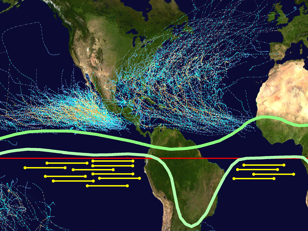
2800 km east-to-west launch loops are shown below the ITCZ and the hurricane belts, in the southern Atlantic between Brazil and Africa, and in the southwest Pacific off Ecuador and Peru. The first launch sites are south of Europe, and the second sites are south of the United States. Unfortunately, there are no good sites south of Asia, or at temperate latitudes. Until launch loops can scale large enough to ignore the wind, wind gusts will be show-stopper. Launch loops are very difficult to build over land, the wind forces are chaotic, and they are too dangerous to locate near cities, so they will only be built over the ocean. As launch loops grow more reliable, and operators become more adept at containing failures, they can be spaced closer together, perhaps within a few kilometers north-south. This, combined with very massive launch loops, means these zones may someday be launching millions of tons into orbit per hour, approaching the cargo capacity of the world's seaports.
Here is a closeup of the launch loop zones east and west of South America:

More About the ITCZ
While it is true that the big whirling hurricanes/typhoons begin 10 or 15 degrees north of the equator, where there is enough Coriolis force to organize a large storm, that does not mean that weather-driven high winds cannot occur elsewhere. There are enormous vertical winds (and hailstones the size of grapefruit!) inside large thunderstorms, and those can occur wherever moist air has lots of buoyancy. The hot air along the equator rises, fed by surface winds from north and south and returning overhead at 10km to 15km altitudes. This circulation is called the Hadley cell. Where the north and south Hadley cells meet is the Inter Tropical Convergence Zone. There is often a line of thunderstorms at the boundary, and the line moves north and south, day by day, season by season. Although a region of the equator may be free of thunderstorms most of the time, they will happen much more frequently as the ITCZ migrates over that region, twice a year.
The ITCZ migrates between the green lines shown on the maps above. Note that the ITCZ kisses the equator off the west coast of South America, but generally stays north of it. 8 degrees south of the equator, 1000km west of land, the ITCZ never appears, and the weather is blissfully boring. There may be low clouds at the atmospheric boundary layer, one or two kilometers up, which will interfere with optical measurements and communication.
A recent report of a thunderstorm at Ascension Island, 8 degrees south. Ascension Island and Galapagos Archipelago weather pictures here.
Propellers
The thrust of an ideal propeller is the force times the velocity through the air. Gossamer aircraft (human and solar powered) approach about 80% of this ideal, but only over a narrow range of velocities. 50% might be a reasonable expectation. If we attempt to generate all the thrust associated with a 20 m/s wind - say 6E6 Newtons - at 50% thrust efficiency, we will need 2 * 20 * 6E6 = 240 MW of thrust power to all the propellers. Probably impractical. However, if we can deflect the average shape of the track into the wind, so that the average rotor deflection force equals the average wind, then our propellers only need to make up the gusting difference, which is probably smaller, localized over kilometer scales, and generating power as often as it requires power. If the gust speeds are 20% of the main speed, the thrust difference ranges from -36% to 44% of 100 kN/km, and the power from -1.5 MW to +1.8 MW per kilometer, perhaps moving the power only a kilometer or two along the track. If the propellers need a few seconds to spin up, we can modulate the thrust more quickly with shutters, or perhaps smaller propellers.
Wind Speed Versus Altitude
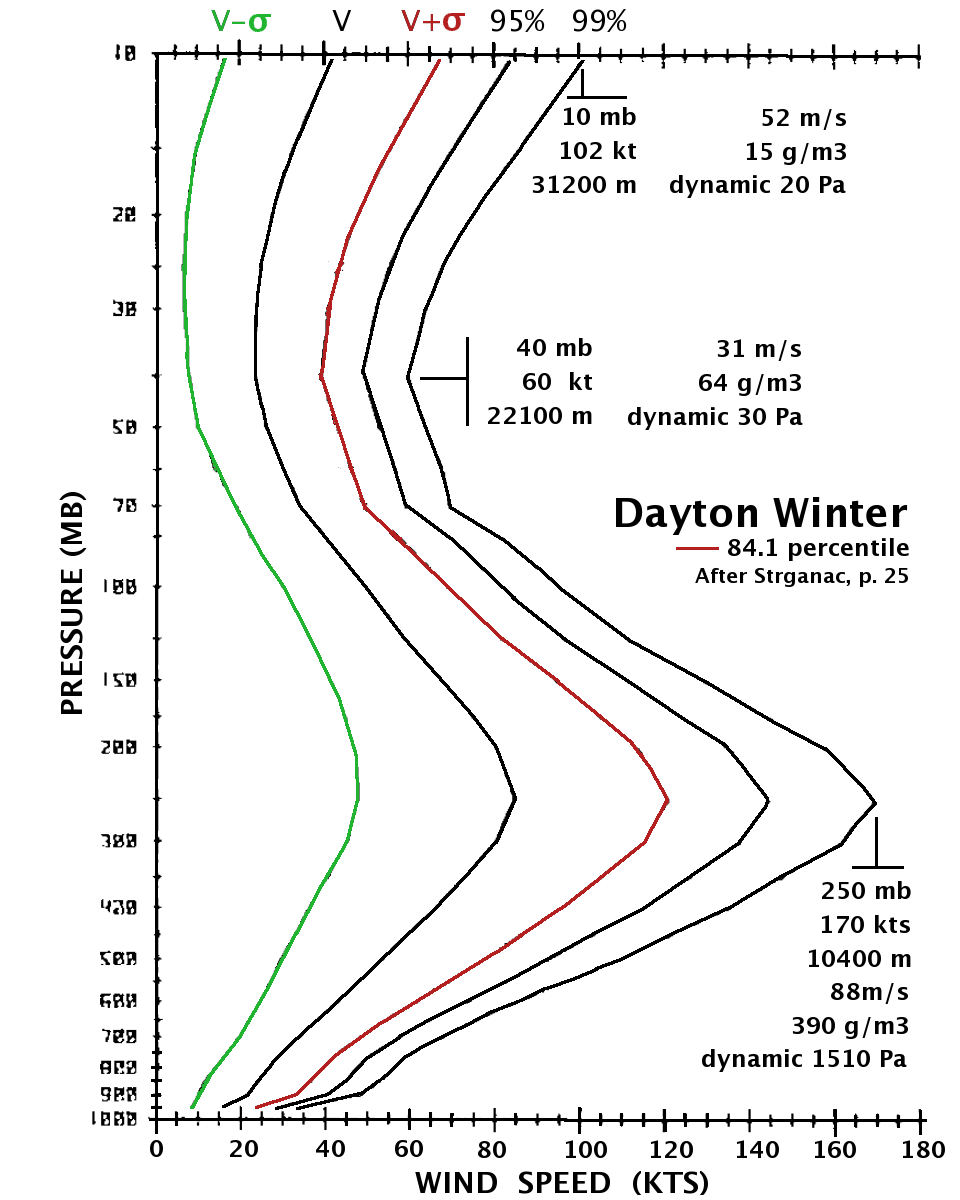
This is a wind speed graph from Strganac, showing the variation in wind over Dayton Ohio. The maximum speed will no doubt be different at the Launch Loop site. The important thing to notice is that the wind at 10km altitude over Dayton varies from an average of 85 knots to a 99th percentile of 170 knots. If this is the day-by-day average, and we want to go 10,000 days (27 years) between catastrophic winds, we are concerned with 99.99% winds; \sigma appears to be 36.5 knots about a mean of 84.5 knots, so the 99.99% percentile ( 3.719\sigma ) is 220 knots. |
MORE LATER:
Wind patterns near the Galapagos? Ascension?
Upper air vortices?
References:
Compatibility of Meteorological Rocketsonde Data as Indicated by International Comparison Tests September 1975. download
see figure 3
Wind study for high altitude platform design, Strganac, T. W., NASA Dec 1, 1979 http://ntrs.nasa.gov/search.jsp?R=19800004408


